
 Sines
Geraz do Lima (Santa Leocádia)
Benavente
Lisbon
Lisbon
Grândola
Matosinhos
Alpedriz
Beja
Sines
Geraz do Lima (Santa Leocádia)
Benavente
Lisbon
Lisbon
Grândola
Matosinhos
Alpedriz
Beja
Image Museum on the map, Braga, Portugal
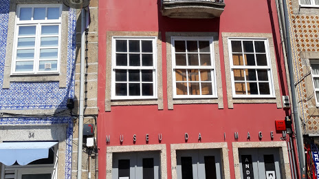
Photo
Where is located Image Museum
Image Museum — local attraction, which is located at Campo das Hortas 35, 4700-421 Braga, Portugal and belongs to the category — museum. Average visitor rating for this place — 4.3 (according to 87 ratings, information from open sources and relevant for 2022).
Exact location — Image Museum, marked on the map with a red marker.
You can get directions to Image Museum on the map from your location.
What else is interesting in Braga? You can see all the sights if you go to the city page.
Coordinates
Image Museum, Portugal coordinates in decimal format: latitude — 41.55031983338057, longitude — -8.429371802202628. When converted to degrees, minutes, seconds Image Museum has the following coordinates: 41°33′1.15 north latitude and -8°25′45.74 east longitude.
Nearby cities
The largest cities that are located nearby:
- Porto — 46 km
- Vigo
 (Spain) — 81 km
 - Ourense (Spain) — 99 km
- Coimbra — 148 km
- A Coruña (Spain) — 201 km
- Salamanca (Spain) — 239 km
- León (Spain) — 260 km
- Oviedo (Spain) — 289 km
- Valladolid (Spain) — 306 km
- Gijón (Spain) — 312 km
- Amadora — 316 km
- Queluz — 316 km
- Badajoz (Spain) — 320 km
- Burgos (Spain) — 396 km
- Móstoles (Spain) — 407 km
- Alcorcón (Spain) — 410 km
- Fuenlabrada (Spain) — 414 km
- Leganés (Spain) — 415 km
- Madrid (Spain) — 417 km
Distance to the capital
Distance to the capital (Lisbon) is about — 320 km.