
 Gilserberg
Berlin
Bordesholm
Bechtolsheim
Aub
Triptis
Heppenheim
Biblis
Angermünde
Gilserberg
Berlin
Bordesholm
Bechtolsheim
Aub
Triptis
Heppenheim
Biblis
Angermünde
Nauener Tor on the map, Potsdam, Germany
Photo
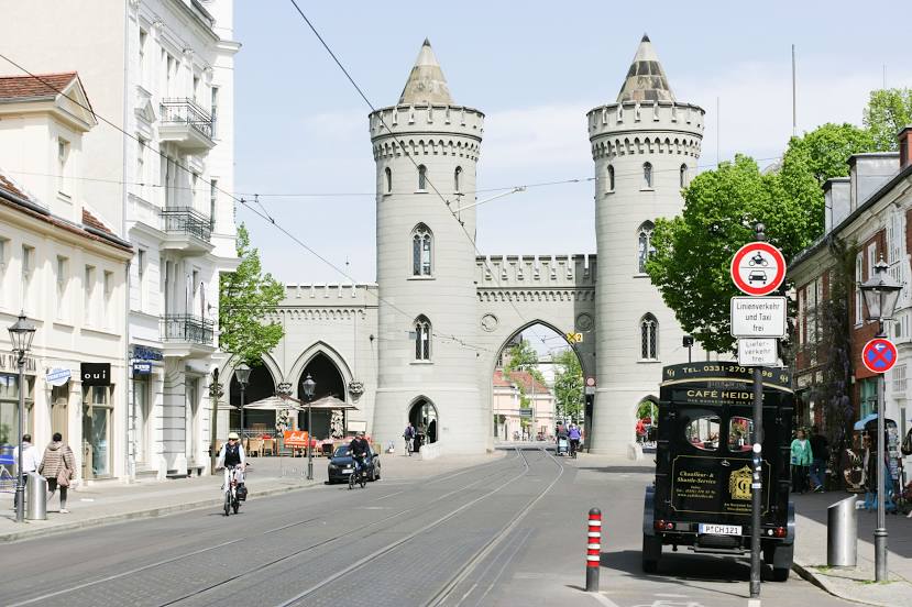
Where is located Nauener Tor
Nauener Tor — local attraction, which is located at Friedrich-Ebert-Straße 32, 14469 Potsdam, Germany and belongs to the category — historical landmark. Average visitor rating for this place — 4.4 (according to 1061 rating, information from open sources and relevant for 2022).
Exact location — Nauener Tor, marked on the map with a red marker.
You can get directions to Nauener Tor on the map from your location.
What else is interesting in Potsdam? You can see all the sights if you go to the city page.
Coordinates
Nauener Tor, Germany coordinates in decimal format: latitude — 52.40307382065691, longitude — 13.056619528186326. When converted to degrees, minutes, seconds Nauener Tor has the following coordinates: 52°24′11.07 north latitude and 13°3′23.83 east longitude.
Nearby cities
The largest cities that are located nearby:
- Berlin — 25 km
- Magdeburg — 102 km
- Cottbus — 112 km
- Leipzig — 126 km
- Gorzów Wielkopolski
 (Poland) — 150 km
 - Szczecin (Poland) — 151 km
- Wolfsburg — 154 km
- Dresden — 155 km
- Brunswick — 172 km
- Chemnitz — 173 km
- Zielona Gora (Poland) — 174 km
- Gera — 180 km
- Salzgitter — 187 km
- Rostock — 198 km
- Erfurt — 210 km
- Hildesheim — 212 km
- Hanover — 225 km
- Göttingen — 236 km
- Legnica (Poland) — 251 km
Distance to the capital
Distance to the capital (Berlin) is about — 27 km.