
 Maureville
Samoëns
Gréning
Toulouse
Volx
Goudet
Méhoncourt
Saint-Hymer
Pontcarré
Maureville
Samoëns
Gréning
Toulouse
Volx
Goudet
Méhoncourt
Saint-Hymer
Pontcarré
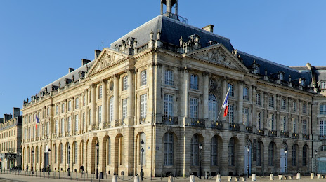
Musée National des Douanes on the map, Bordeaux, France
Photo
Where is located Musée National des Douanes
Musée National des Douanes — local attraction, which is located at 1 Pl. de la Bourse, 33000 Bordeaux, France and belongs to the category — museum. Average visitor rating for this place — 4.2 (according to 289 ratings, information from open sources and relevant for 2022).
Exact location — Musée National des Douanes, marked on the map with a red marker.
You can get directions to Musée National des Douanes on the map from your location.
What else is interesting in Bordeaux? You can see all the sights if you go to the city page.
Coordinates
Musée National des Douanes, France coordinates in decimal format: latitude — 44.84079654169546, longitude — -0.5700444750084755. When converted to degrees, minutes, seconds Musée National des Douanes has the following coordinates: 44°50′26.87 north latitude and -0°34′12.16 east longitude.
Nearby cities
The largest cities that are located nearby:
- Limoges — 179 km
- San Sebastián
 (Spain) — 202 km
 - Toulouse — 212 km
- Pamplona (Spain) — 240 km
- Bilbao (Spain) — 257 km
- Nantes — 273 km
- Vitoria-Gasteiz (Spain) — 277 km
- Angers — 292 km
- Tours — 298 km
- Santander (Spain) — 301 km
- Clermont-Ferrand — 301 km
- Logroño (Spain) — 304 km
- Zaragoza (Spain) — 354 km
- Le Mans — 355 km
- Perpignan — 369 km
- Lleida (Spain) — 370 km
- Rennes — 372 km
- Burgos (Spain) — 375 km
- Montpellier — 382 km
Distance to the capital
Distance to the capital (Paris) is about — 499 km.